Seawall guides by key. Find your canal, bight or harbor.
Pick your key to see who permits seawall work there, the canals and storm records that matter, and what to ask first. The 17 guides fall into three groups: Key West and Stock Island, the Lower Keys, and the Middle Keys. Key West, Marathon, Key Colony Beach and Layton issue their own permits, and Monroe County handles the rest.
Find your key
Explore the coast. Find your starting point.
From Key West to Long Key, each guide covers who issues the permit, what the water and the storms did there, and what to check on your wall.
Full local guide
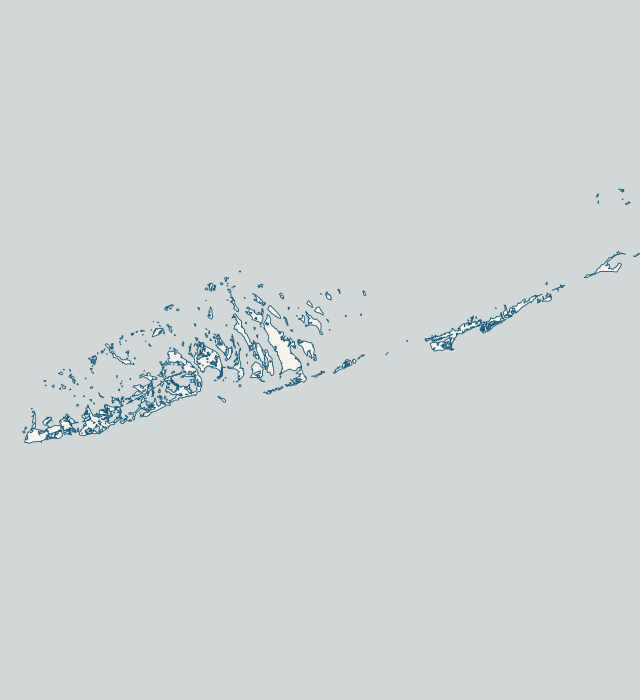
Choose a label to open local resources →Tap a community on the map or below ↗
Land and water: U.S. Census Bureau TIGERweb, 2026. Reference points: USGS GNIS. General orientation only; not a survey, flood map or service boundary.
Your local starting point
Find your community.
Choose a guide for local maps, permit starting points and the records to gather for your property.
Old Town is Key West’s high ground and its oldest waterfront. NWS notes that land above 8 ft MSL across much of Old Town blocked Wilma’s surge, yet flooding began along the Old Town waterfront and Garrison Bight. City Marina’s 245 slips straddle the Palm Avenue causeway there, including Historic Charter Boat Row. The Key West tide gauge, with records back to 1913, logged its highest reading during Wilma on Oct. 24, 2005.
New Town’s residential waterfront is the Riviera Canal, which the county inventory lists as canal 480: 211 parcels along about 10,600 ft, with two mouths. Flagler Avenue, one of its streets, is set for a county drainage rebuild with pumps and injection wells. On the south shore, Wilma left pieces of seawall on South Roosevelt Boulevard near Smathers Beach, and salt water reached Flagler east of First Street by 3:01 a.m.
Key Haven, called Key Haven/Raccoon Key in the county road study, is a bayside canal neighborhood at mile marker 5. Its homes use Key West addresses, yet the city’s floodplain page places it outside city limits and under Monroe County. Five canals numbered 457 to 473 serve 428 parcels along roughly 9,600 ft of water.
Stock Island is an unincorporated census place with less than one square mile of land and more water than land inside its boundary. Its waterfront mixes marinas and fishing facilities with water treatment and power plants, mobile home parks and housing. Only two residential canals appear in the county inventory. A Monroe County permitting office sits on the island at 5503 College Road.
Big Coppitt is an unincorporated census place whose canals sit at mile markers 10 and 11, with Rockland, Geiger and the Saddlebunch Keys nearby, all county land. Big Coppitt’s 14 canals are mostly bayside, while all 20 of Geiger Key’s canals sit on the ocean side. The county calls Big Coppitt Hot Spot 2 for 2040 sea-level rise and high tide flooding, and has designed a road elevation project for 19 of its streets.
Sugarloaf Key covers mile markers 17 to 20 in the county canal inventory, with Upper Sugarloaf and Lower Sugarloaf Shores. Its 55 canal sections are mostly oceanside, and Sugarloaf Boulevard alone touches 25 of them. Tide range fields are low, about 0.4 to 0.8 ft. In Irma, Sugarloaf sat just west of Cudjoe Key, where the Hurricane Center’s inundation estimate jumped from 2 to 4 ft up to 5 to 8 ft.
Cudjoe Key is slightly more water than land: its census area holds about 5.3 square miles of water against 5.2 of land. The county lists 46 residential canal sections here, numbered 312 to 380 between mile markers 21 and 23. All but one are on the ocean side, and together they front 1,503 parcels.
Summerland is a compact key at mile markers 24 and 25. The county lists 13 residential canals here, 11 of them oceanside, serving 634 parcels along about 15,250 feet. The same short stretch holds Summerland Airfield and private marinas that the county flags as a long-term sea-level-rise hot spot.
Ramrod sits at mile marker 27 with three county canals: 310, 311 and 350. Canal 350 runs about 6,000 feet past Indies Drive and lanes named for Caribbean islands, from Anguila to St Vincent. Beneath the key, USGS maps a change in rock type on its south side.
The three Torch Keys share a name but not a waterfront. Little Torch has seven county canals at mile marker 29, five bayside and two oceanside, serving 651 parcels. Big Torch has one bayside canal, 262, with 67 parcels. The county lists no residential canals on Middle Torch.
Big Pine has about 10.2 square miles of land. The county lists 45 canal sections here, 38 of them bayside, fronting 2,529 parcels along roughly 56,400 feet. The National Key Deer Refuge is based here, and Coupon Bight Aquatic Preserve lies off the south shore.
No Name Key sits at mile marker 34. Its two county canals front 134 parcels on the bay side. Canal 261 has an existing culvert and canal 265 a weed gate. Spanish Channel Drive, Bahia Shores Drive and No Name Road (State Road 4A) are among the streets on 261.
Marathon runs from the east end of the Seven Mile Bridge, about mile marker 47, to the Toms Harbor bridge near MM 60. Key Colony Beach, in the middle, is a separate city. Inside Marathon, the county lists 86 residential canals, 67 of them oceanside. Boot Key Harbor holds the City Marina at 800 35th Street.
This is Marathon's east end, running up to the Toms Harbor bridge near mile marker 60. Curry Hammock State Park holds all of Little Crawl Key and Deer Key and parts of Fat Deer and Long Point Keys. The county lists only a handful of residential canals, on Grassy Key and Crawl Key.
Key Colony Beach is its own city of 286 acres at mile marker 53.5, surrounded by Marathon. Its 11 canals all run to the ocean side, and most homes sit on one. The island was pumped up from about 97 acres of low ground in the early 1950s, and its first seawalls were cypress timber.
Duck Key sits at about mile marker 61, just past Marathon's limit at the Toms Harbor bridge. Four historic arch bridges tie its islands together, and the Toms Harbor Channel Bridge links it to U.S. 1. Its single canal system opens to the water through five mouths.
Layton is a city of about 208 residents on Long Key, with City Hall at 68280 Overseas Highway. Long Key State Park takes up about 1,002 acres of the island. Conch Key, at mile marker 63, is a low county island already in line for road elevation.