
Sugarloaf Key seawall repair: long canals, small tides
Sugarloaf Key has 55 county-listed canal sections, most of them oceanside, with little tide moving through them. Monroe County permits seawall and dock work on both Upper and Lower Sugarloaf.
Describe your project on this page ↓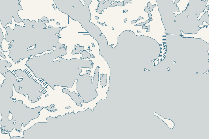
Sugarloaf Key & Sugarloaf Shores at a glance
- Who permits it
- Monroe County Building Department
- Call first
- County Big Pine Key office, (305) 289-2877
- The water
- 55 canal sections, 48 oceanside, serving 653 parcels
- Tide
- Canal tide-range fields of about 0.4 to 0.8 ft
- Storm record
- Irma: 2 to 4 ft west of Cudjoe, 5 to 8 ft from Cudjoe east
Get to know your waterfront
Sugarloaf Key covers mile markers 17 to 20 in the county canal inventory, with Upper Sugarloaf and Lower Sugarloaf Shores. Its 55 canal sections are mostly oceanside, and Sugarloaf Boulevard alone touches 25 of them. Tide range fields are low, about 0.4 to 0.8 ft. In Irma, Sugarloaf sat just west of Cudjoe Key, where the Hurricane Center’s inundation estimate jumped from 2 to 4 ft up to 5 to 8 ft.
Monroe County Residential Canals (Google Earth KMZ layer 'Residential_Canals_WGS', linked as 'Google Earth Document with Downloaded Canal Information') · Canal, Roads Names and Areas (List of Keys Residential Canals by location) · Tropical Cyclone Report: Hurricane Irma (AL112017), current version dated 8 July 2026
Low tides, long canals: reading a Sugarloaf shoreline
Sugarloaf sits right where Irma’s surge changed. The Hurricane Center found 5 to 8 ft of inundation from Cudjoe Key east, and 2 to 4 ft from west of Cudjoe to Key West. Sugarloaf lies on the western, lower side of that line. Hurricane Center Irma report
Its canals are quieter most days. The county lists 55 canal sections on Sugarloaf, 48 of them oceanside, serving 653 parcels along about 41,500 ft. Their tide range fields run only about 0.4 to 0.8 ft. County canal inventory
Find your canal
- Sugarloaf Boulevard: tied to 25 canal numbers between 387 and 430.
- Lower Sugarloaf: Shore Drive, Westpoint Drive, South Point Drive, Venetian Way and the fish lanes: Bonefish, Bonita, Kingfish, Starfish, Angelfish, Wahoo and Amberjack.
- Upper Sugarloaf: Crane Boulevard, Loggerhead Lane and Hawksbill Lane, on canal 307.
These links come from the county lookup, and one street can touch several canals. County canal street list Canal 430 has a connector cut through to give it two mouths. County canal inventory
Slow water and the restoration list
The county says many Keys canals are too deep, with too little tidal flushing, so they trap stormwater, debris and dead seagrass. County canal restoration requests With tides this small, many Sugarloaf canals likely flush slowly.
| Canal | Rank, of 96 | Planning estimate |
|---|---|---|
402 | 5th | $210,523 (backfill and weed gate) |
403 | 10th | $804,157 |
388 | 76th | $9,214,221 |
384 | 86th (“Poor”) | $7,159,702 |
Other Sugarloaf canals on the list include 411 (53rd), 413 (62nd), 318 (64th) and 385 (67th). 2021 county canal ranking These are public water-quality estimates, never seawall prices. Ask the canal program at (305) 453-8774 if yours is scheduled. County canal restoration page
Sewer hookups matter to canal water too. Upper Sugarloaf had the lowest connection rate the state monitored, with 73 percent of its 592 equivalent dwelling units connected. FloridaCommerce Keys oversight report
Roads in the county flood study
- Lower Sugarloaf has 50 road segments, about 27,437 ft, on the county’s list of its most critical roads, across Sugarloaf Shores and Orchid Park. County critical roads list
- The study’s 2025 group includes Upper Sugarloaf along SR 939B (4,512 ft, criticality 4.89) and Sugarloaf Shores sections A-F with Orchid Park (3,630 ft). County road study
- The larger Sugarloaf Shores area, 31,857 ft, falls in the 2035 group. County road study
- The county singles out Upper Sugarloaf’s Johnson Road as a segment it already knew was very vulnerable. County critical roads list
- Sugarloaf Key is Hot Spot 5, at risk from present-day rainfall and future sea-level rise, with the school and an FKAA lift station on the list. County vulnerability assessment
Key deer range reaches Sugarloaf
The county says more than 85 percent of Key deer live on Big Pine and No Name, with other deer found through mile marker 16. State of the County 2023 Sugarloaf’s canals sit at mile markers 17 to 20, inside that range. County canal inventory
The federal species focus area maps, not the mile marker, decide if your permit goes to Fish and Wildlife. Ask county environmental staff to check your parcel before design. Monroe County code Ch. 122
During Wilma, the NOAA Weather Radio transmitter on Sugarloaf went silent when its generator’s fuel tank floated away. NWS Key West Wilma summary For a dock alongside the wall, see docks and boat lifts.
What could the work cost?
Sugarloaf’s canal system runs about 41,500 ft, so a barge may travel a long way to reach your lot. Ask each bidder how they will get there and what that adds, and keep dock or lift work as a separate line from the wall.
Calculator ranges come from a 2026 national cost guide and one Key West public bid. None is a quote; your written, itemized scope sets your price.
Compare quotes and plan a budget →Find the relevant permits and records
| Starting point | What to resolve | Prepare and look up |
|---|---|---|
Monroe County Building Department | Building permits for seawall, dock and riprap work across Upper and Lower Sugarloaf. | Apply through OPAL. Nearest office: Big Pine Key satellite, 179 Key Deer Blvd., (305) 289-2877. |
Monroe County Planning & Environmental Resources | county code 118-12 shoreline review and the species focus area check. | Request a species map check for your lot. (305) 289-2502; $825 county fee if the file goes to FWS. |
Florida DEP Marathon branch | Canal seawall exemption, and dock exemptions up to 1,000 sq ft in dredged canals. | (305) 289-7070. Ask whether the canal bottom is state-owned before planning a new dock. |
Army Corps Keys Permits Section | Federal authorization for in-water work. | (305) 526-7181. The state-run federal shortcut, SPGP VI, excluded most Monroe County work and expired July 27, 2026. |
A Sugarloaf planning checklist
Four things a Sugarloaf owner can do this week.
Match your street to a canal number
Use the county’s Residential Canals map file to confirm your canal number, depth and ranking. Sugarloaf Boulevard alone touches 25 canals.
Canal, Roads Names and Areas (List of Keys Residential Canals by location) · Canal Restoration
Check the species maps early
Ask county environmental staff if your parcel is in a species focus area. If it is, the permit can be held until Fish and Wildlife weighs in.
Monroe County Land Development Code, Chapter 122 - Floodplain Management · State of the County 2023
Photograph king tides
The county expects king tides from September through December and asks for flood photos with address, date and time at greenkeys@monroecounty-fl.gov. The same photos record how water meets your cap.
Time any seagrass survey
If a new dock or riprap could reach seagrass, the sanctuary’s survey window runs June 1 to September 30. Plan around it.
Resource Assessment Survey Protocols for Nearshore Construction Projects
Plan your Sugarloaf seawall repair
Tell us your street, which side of the island you are on and what you see along the wall. We will help you sort out the permit path and the next step.
Every answer here links to the public record behind it.
Sugarloaf Key & Sugarloaf Shores project questions
Which canals run along Sugarloaf Boulevard?
The county ties Sugarloaf Boulevard to 25 canal numbers between 387 and 430. Lower Sugarloaf’s fish-named lanes and Upper Sugarloaf’s Crane Boulevard area, on canal 307, sit on others. Confirm your parcel on the county map, since one street can touch several canals.
Canal, Roads Names and Areas (List of Keys Residential Canals by location)
Did Irma hit Sugarloaf as hard as Cudjoe Key?
Sugarloaf lies in the stretch the Hurricane Center describes as west of Cudjoe Key, where Irma’s inundation was 2 to 4 ft. From Cudjoe east to Big Pine, it reached 5 to 8 ft. Water at any one lot depended on ground height and exposure.
Tropical Cyclone Report: Hurricane Irma (AL112017), current version dated 8 July 2026
Is my Sugarloaf canal on the restoration list?
Several are. On the 2021 draft ranking, canal 402 placed 5th and 403 placed 10th, while 388 and 384 sit near the bottom. Call the county canal program at (305) 453-8774 for current plans.
Monroe County Canal Restoration Ranking List (dated 06/16/2021; page footer 4/12/2021) · Canal Restoration
Do Key deer rules apply on Sugarloaf?
They can. The county says Key deer are found as far west as mile marker 16, which takes in Sugarloaf. Federal species focus area maps decide if your permit goes to Fish and Wildlife, with an $825 county fee if it does.
State of the County 2023 · Monroe County Land Development Code, Chapter 122 - Floodplain Management · Resolution No. 277-2025 (Building Department permitting fee schedule)
Keep planning
Nearby waterfront guides
Big Coppitt, Rockland & Geiger Key, Cudjoe Key & Cudjoe Gardens, Summerland Key
Show sourcesHide sources
- Monroe County Residential Canals (Google Earth KMZ layer 'Residential_Canals_WGS', linked as 'Google Earth Document with Downloaded Canal Information')Source reviewed 2026-10-28
- Canal, Roads Names and Areas (List of Keys Residential Canals by location)Source reviewed 2026-10-28
- Tropical Cyclone Report: Hurricane Irma (AL112017), current version dated 8 July 2026Source reviewed 2026-10-28
- Water Quality Protection and Canal Restoration in the Florida Keys ACSC: DEP Stewardship Funding Portal Project RequestsSource reviewed 2026-10-28
- Monroe County Canal Restoration Ranking List (dated 06/16/2021; page footer 4/12/2021)Source reviewed 2026-10-28
- Canal RestorationSource reviewed 2026-10-28
- Florida Keys Area of Critical State Concern Annual Report, FY23-24 (reporting period July 1, 2023 - June 30, 2024)Source reviewed 2026-10-28
- Appendix K: Prioritization of Roadway Segments (Technical Memorandum, Dec. 29, 2020; Initial 25% Critical Roadways list dated 6/10/2021)Source reviewed 2026-10-28
- Monroe County Roadway Vulnerability Study Final Report (Table 2: Adaptation Plan List)Source reviewed 2026-10-28
- Monroe County Vulnerability Assessment Update & Compliance, Final Project Report (DEP Agreement No. 22PLN66)Source reviewed 2026-10-28
- State of the County 2023Source reviewed 2026-10-28
- Monroe County Land Development Code, Chapter 122 - Floodplain ManagementSource reviewed 2026-10-28
- Hurricane Wilma (2005) event summarySource reviewed 2026-10-28
- Building and PermittingSource reviewed 2026-10-28
- Online Permitting ServicesSource reviewed 2026-10-28
- Environmental ResourcesSource reviewed 2026-10-28
- Resolution No. 277-2025 (Building Department permitting fee schedule)Source reviewed 2026-10-28
- SED Marathon OfficeSource reviewed 2026-10-28
- Section 403.813, Florida Statutes (2026)Source reviewed 2026-10-28
- Rule 18-21.005, F.A.C. (Forms of Authorization)Source reviewed 2026-10-28
- Jacksonville District Regulatory Office LocationsSource reviewed 2026-10-28
- State Programmatic General Permit (SPGP) VISource reviewed 2026-10-28
- King Tides & High TidesSource reviewed 2026-10-28
- Resource Assessment Survey Protocols for Nearshore Construction ProjectsSource reviewed 2026-10-28